The Stanley Park Seawall’s magnificent views are often disrupted by friction between users. The key isn’t just knowing the rules, but understanding the unspoken social contract of this shared space.
- Path etiquette is about predictable movement: walkers stay seaside, wheels stay inside, and everyone moves counter-clockwise.
- True enjoyment comes from “path awareness”—knowing when to escape crowded areas for tranquil interior trails.
- Respect extends beyond people to the park’s cultural sites and fragile ecosystems.
Recommendation: Approach your visit not as a race, but as a practice in courtesy. Moving with awareness and consideration is the only way to truly experience the magic of the Seawall.
Welcome to the jewel of Vancouver. As a park ranger, I see thousands of people enjoy the Stanley Park Seawall every week, but I also see the daily friction: the near-misses between cyclists and pedestrians, the confusion at intersections, and the frustration that bubbles up on a sunny day. Many guides will tell you the basic rules, like staying in your lane or the direction of travel. These are essential, of course, but they are only half the story. They are the ‘what’, not the ‘why’.
The real secret to navigating the Seawall isn’t just following a list of regulations. It’s about embracing a mindset of shared responsibility and developing what I call “spatial intelligence.” It’s about understanding the flow dynamics of a path that’s both a commuter highway and a leisurely stroll. The conflict you feel isn’t personal; it’s a design challenge that can only be solved by human courtesy. This guide is built on a park ranger’s perspective. It goes beyond the signs to explain the unwritten etiquette that transforms a potentially stressful outing into a seamless, beautiful experience for everyone.
We’ll explore the critical differences between the paths, find serene escapes from the crowds, and discuss how to show respect not just to fellow visitors, but to the land and its history. This is your guide to moving through Stanley Park with the confidence and grace of a local.
To help you navigate this iconic Vancouver experience, this article covers everything from on-path etiquette to discovering the park’s deeper stories. Explore the sections below to plan your perfect visit.
Summary: A Ranger’s Guide to the Stanley Park Seawall
- Bike Lane vs. Walking Path: Why Crossing the Line is Dangerous
- Beaver Lake and Beyond: Escaping the Seawall Crowds
- Third Beach vs. English Bay: Where to End Your Walk for the Best Sunset?
- Why You Should Pay by App for Parking in Stanley Park
- How to Visit the Brockton Point Totems Respectfully
- Architecture by the Water: The Best Route to See the Glass Towers
- How to Photograph Giant Douglas Firs Without Trampling the Undergrowth
- Vancouverism: How Urban Design Created the City of Glass
Bike Lane vs. Walking Path: Why Crossing the Line is Dangerous
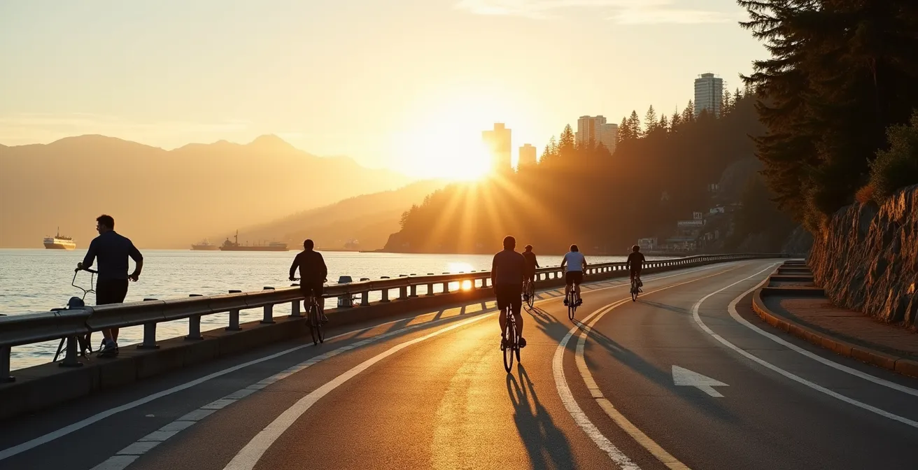
The single most important concept to grasp on the Seawall is the ‘Shared Space Contract’. It’s an unspoken agreement that you will respect the designated lanes. The painted line isn’t a suggestion; it’s a critical safety barrier. The ocean-side path is for pedestrians only. The inner path is for faster-moving wheels: cyclists, rollerbladers, and skateboarders. Crossing this line unexpectedly is the number one cause of accidents I see in the park. Think of it this way: a cyclist moving at 15 km/h has no way to stop if a pedestrian suddenly steps out from behind a group to take a photo.
This entire system works because of one fundamental rule: predictable movement. Everyone—walkers, joggers, and cyclists—must travel in a counter-clockwise direction around the park. This creates a consistent flow and eliminates the danger of head-on collisions. According to the City of Vancouver, the 10-km or 13,123-step seawall loop is the city’s most popular attraction, and managing that volume of people safely depends entirely on this rule. To truly master the Seawall, you must internalize these core principles of path awareness.
Actionable Plan: Essential Seawall Safety Rules
- Stay in your designated lane: Walkers and joggers use the ocean-side path. Cyclists and rollerbladers use the inner path. No exceptions.
- Follow the counter-clockwise rule: All wheeled users must travel counter-clockwise around the park. Pedestrians are encouraged to do the same for predictable flow.
- Cross at designated points only: Look for marked crosswalks when you need to switch sides or access an exit. Never dart across the bike lane.
- Be aware of peak hours: Avoid crossing lanes during commuter rush hours (7-9 am and 5-7 pm on weekdays) when cyclist traffic is heaviest.
- Watch for ‘Dismount’ signs: Certain congested or narrow areas, like near the totem poles, require cyclists to get off and walk their bikes for everyone’s safety.
By treating the lanes with the same respect you’d give to lanes on a highway, you contribute to a safer, more enjoyable experience for the millions who use this path each year.
Beaver Lake and Beyond: Escaping the Seawall Crowds
While the Seawall offers iconic ocean views, its popularity can sometimes feel overwhelming. A key part of spatial intelligence is knowing when to retreat from the crowds. Stanley Park has over 27 kilometres of forest trails that offer a completely different, and often more profound, experience. Trading the wide-open vistas for the quiet sanctuary of the forest is the local’s secret to truly appreciating the park’s scale and natural beauty. Trails like Tatlow, Merilees, and Rawlings offer immediate immersion into a world of towering trees and filtered sunlight, far from the buzz of the Seawall.
The heart of this inland network is Beaver Lake. What was once a 10-acre lake is slowly being reclaimed by nature, particularly by the invasive water lilies introduced in 1938. As confirmed by park historians, this ecological shift has created a unique wetland habitat. It’s a place of quiet observation where you can see beavers, various fish, and countless water birds. More importantly, Beaver Creek, which flows from the lake, is one of only two streams in Vancouver where salmon still return to spawn each year. Visiting this area is a chance to witness a living ecosystem at work.

As you can see, the interior trails provide a peaceful contrast to the bustling Seawall. To find these quiet routes, simply look for the trail entrances along Stanley Park Drive or use one of the access points directly from the Seawall, such as the path near Siwash Rock. A few minutes of walking inland can feel like entering another world.
This isn’t just about avoiding people; it’s about experiencing the full, diverse character of Stanley Park, from its roaring shoreline to its silent, mossy heart.
Third Beach vs. English Bay: Where to End Your Walk for the Best Sunset?
Planning the end of your Seawall walk is as important as the walk itself, especially if you’re aiming for a spectacular sunset. The two most popular choices, Third Beach and English Bay, offer vastly different experiences. Your decision should be based on the atmosphere you’re seeking. Third Beach, nestled right within the park, has a distinctively bohemian and local vibe. It’s more secluded, backed by trees, and famous for its lively drum circles on sunny evenings. It feels like a natural cove and is perfect for a quiet, contemplative end to your day.
In contrast, English Bay Beach marks the edge of the park and the beginning of the city’s West End neighbourhood. The energy here is urban and vibrant. You’re surrounded by restaurants on Denman Street, public art installations like A-maze-ing Laughter, and a constant flow of people. The sunset view here includes the city skyline and the silhouettes of container ships waiting in the bay, offering a completely different photographic opportunity. While more crowded, its direct access to transit and amenities makes it a convenient and energetic place to finish your journey.
To help you decide, here is a direct comparison of what to expect at each location. As this breakdown from Vancouver’s Best Places shows, the right choice depends entirely on your personal preference for either natural tranquility or urban energy.
| Feature | Third Beach | English Bay |
|---|---|---|
| Atmosphere | Bohemian, local vibe with weekly drum circles | Urban energy with street performers |
| Crowds | Less crowded, more locals | Tourist hotspot, very busy |
| Facilities | Concession stand, lifeguards in summer | Multiple restaurants on Denman Street |
| Transit Access | 15-minute walk to bus stop | Direct bus connections |
| Parking | Limited lot, often full by afternoon | Street parking plus nearby parkades |
| Photography | Natural silhouettes against ocean | City skyline and container ships in frame |
Whichever you choose, both beaches provide a front-row seat to one of Vancouver’s most celebrated daily spectacles.
Why You Should Pay by App for Parking in Stanley Park
Nothing ruins a peaceful walk more than “meter dash” anxiety—the nagging worry that your parking is about to expire. In a park as large as Stanley Park, returning to a pay station can mean a 20-minute walk, interrupting your experience. This is precisely why, as a ranger, I strongly recommend using a parking app. The official provider, EasyPark, eliminates this stress entirely. It allows you to extend your parking session remotely from anywhere, whether you’re admiring the totem poles or enjoying the sunset at Third Beach.
The convenience far outweighs the minimal cost. According to the EasyPark app’s own FAQ, they charge only a 20-cent convenience fee per transaction. For that small price, you receive an alert 10 minutes before your time is up, giving you ample opportunity to add more time right from your phone. This is a game-changer for anyone planning to stay longer than an hour or two. Furthermore, remember that a day pass is often the most economical option if you’re staying over four hours, and it’s valid in any of the park’s lots, giving you the flexibility to drive from one area to another.
Parking rates are seasonal, so it’s wise to check them before you arrive. The current rates are published by EasyPark and local partners. For instance, data shows that summer rates (April-September) are typically around $3.75 per hour or $14.25 for the day, while winter rates are lower. A crucial rule to remember is that overnight parking is prohibited throughout the park from 11 pm to 6 am. Using an app not only simplifies payment but also helps you keep track of these rules and time limits effortlessly.
By downloading the app before you go, you are setting yourself up for a much more relaxed and flexible visit.
How to Visit the Brockton Point Totems Respectfully
The totem poles at Brockton Point are arguably the most visited cultural site in all of British Columbia. However, to visit them with respect, we must first acknowledge the land itself. This is not just a park; it is a place of deep historical and cultural significance. As the City of Vancouver officially recognizes, this is ancestral land.
Stanley Park is on the unceded territories of the Musqueam, Squamish and Tsleil-Waututh peoples.
– City of Vancouver, Official Stanley Park Seawall Guide
This acknowledgement frames our visit. We are guests here. The second piece of crucial context is understanding what the totem poles represent. Many visitors assume they are standing in an ancient village. In reality, the collection is more of a spectacular outdoor art gallery. The majority of the poles you see today were carved in the 1980s to replace the originals from the 1920s and ’30s, which were moved to museums for preservation. They represent the artistry of various First Nations from across British Columbia, not just the local nations. They are a celebration of living, evolving cultural traditions.
Respectful visitation, therefore, means two things. First, it means giving the poles space. Use the designated pathways and viewing areas. Never touch the carvings or climb on the structures for a photo. Second, it means taking a moment to read the interpretive signs. Learn about the artists and the stories they tell. This act of learning is an act of respect. It shifts your role from a passive tourist to an engaged and appreciative guest, honouring both the art and the land it stands upon.
Your visit becomes more meaningful when you appreciate the poles not as ancient relics, but as powerful expressions of enduring cultures on their ancestral lands.
Architecture by the Water: The Best Route to See the Glass Towers
Your Seawall journey doesn’t have to start within Stanley Park. The path is part of a much larger network, and one of the most stunning approaches is through Coal Harbour, which connects the Vancouver Convention Centre to the park’s entrance. This section offers the best vantage point to witness “Vancouverism” in action—the city’s world-renowned style of urban design. Here, the Seawall acts as a public promenade, weaving between sleek glass towers and the bustling marina. It’s a perfect fusion of urban density and natural beauty.
This route is a self-guided architectural tour that showcases some of the city’s most iconic modern structures. The podium-tower design, a hallmark of Vancouverism, is on full display here. These buildings feature wide bases with townhouses and shops to create a vibrant street-level experience, while slender glass towers rise above to preserve view corridors for residents behind them. It’s a design philosophy that prioritizes public access and community life, and the Seawall is its greatest expression. Walking this stretch, you are literally experiencing the blueprint of the modern city.
For the best experience, follow this simple route:
- Start your walk at Canada Place to admire its iconic white sail roof, designed to evoke the region’s maritime history.
- Continue west past the Vancouver Convention Centre, with its living green roof and dramatic glass façade.
- Pause at the Olympic Cauldron, a powerful legacy from the 2010 Winter Games.
- Proceed into Coal Harbour, where the pathway winds past marinas filled with yachts, offering the best views of the podium-tower architecture.
- End your architectural tour near Harbour Green Place to see the signature style of James K.M. Cheng, one of the key architects of the Vancouver look.
This short walk provides a powerful lesson in how thoughtful urban design can create a city that feels both exciting and intimately connected to its waterfront.
How to Photograph Giant Douglas Firs Without Trampling the Undergrowth
The desire to capture the majesty of Stanley Park’s old-growth forest is universal. The towering Douglas firs and Western Red Cedars create a natural cathedral that begs to be photographed. However, this enthusiasm often leads to a significant problem: soil compaction and damage to the fragile forest undergrowth. As a ranger, I frequently see visitors stepping off marked trails to get the “perfect shot,” unaware that the delicate network of ferns, mosses, and shallow tree roots they are trampling can take years to recover. Respecting the park means protecting it, even from our own feet.
Fortunately, you don’t need to be a trailblazer to get incredible photos. The park has been designed with photographers in mind. A prime example is the Hollow Tree, a massive, 700 to 800-year-old Western Red Cedar stump. It is one of the most photographed landmarks in Vancouver. To protect the surrounding area from its popularity, the park has built designated viewing platforms and reinforced pathways. This allows thousands of visitors to get their iconic photo without causing any ecological damage. This is the model for ethical photography: use the infrastructure provided.
To capture the forest giants without leaving a trace, follow these simple guidelines. Your best tools are patience and a willingness to stay on the path.
- Use the designated viewpoints, especially along Beaver Lake Trail and Rawlings Trail, which are known for their spectacular old-growth shots.
- Stay on the paved or gravel trails at all times. The best photographers find creative angles from the path, not by venturing into the woods.
- Photograph the forest from the edge of the Seawall, looking inward. This perspective can create beautiful compositions with the water in the foreground.
- Bring a telephoto lens if you have one. It allows you to capture details of the bark or canopy high above without ever leaving the trail.
- For a guided experience, visit the Stanley Park Nature House at the southern foot of the park, as they often have information on guided walks that focus on respectful nature photography.
A truly great nature photograph is one that honours its subject by leaving it completely undisturbed.
Key takeaways
- The Seawall operates on a ‘Shared Space Contract’: respect designated lanes and the counter-clockwise flow to ensure safety for all.
- Escape the crowds by exploring the park’s interior trails; places like Beaver Lake offer tranquility and a deeper connection to nature.
- Visiting cultural sites like the Brockton Point totems requires understanding—they are a gallery of living art on unceded territory, not an ancient village.
Vancouverism: How Urban Design Created the City of Glass
The Stanley Park Seawall is more than just a recreational path; it is the crowning achievement of a city planning philosophy known as Vancouverism. This philosophy prioritizes public access to the waterfront, high-density living, and the integration of natural landscapes into the urban fabric. The fact that you can walk or cycle on 28 km of uninterrupted waterfront pathway from the Convention Centre to Spanish Banks Beach is a direct result of this forward-thinking vision. It is the longest continuous waterfront path in the world, and it exists because city planners consistently chose public access over private development.
This was a century-long project born from incredible foresight. Construction of the Stanley Park section began in 1917 under the guidance of master stonemason James Cunningham, who dedicated 35 years of his life to the project. For decades, the wall was built piece by piece, a monumental undertaking that was only officially completed on September 21, 1980. Every stone in that wall represents a commitment to the idea that the city’s most beautiful asset—its shoreline—should belong to everyone. It is the physical manifestation of Vancouver’s identity as a ‘City of Glass’ nestled against the forest and the ocean.
When you use the Seawall, you are participating in this legacy. You are part of an urban experiment that has been globally praised. The courtesy and respect you show to others on the path, the appreciation you have for the nature around you, and your understanding of the park’s cultural history all contribute to the success of this shared public space. It is a living example of how a dense city can remain deeply connected to nature.
Your journey along its edge is a journey through the very heart of what makes this city special. The next logical step is to carry this awareness with you on every visit, becoming an active steward of this incredible public space.