In summary:
- Quebec’s fortifications are not just scenic walls but a masterclass in military architecture, designed to leverage the city’s unique clifftop topography.
- The star-shape of the Citadelle and the layout of the ramparts were engineered to create deadly, overlapping “fields of fire” against any attacker.
- The historic division between the elite Upper Town and the working Lower Town is a key to understanding the city’s social history, now bridged by the funicular.
- The Battle of the Plains of Abraham’s famous brevity (under 20 minutes) was a direct result of disciplined British military tactics that reshaped North America.
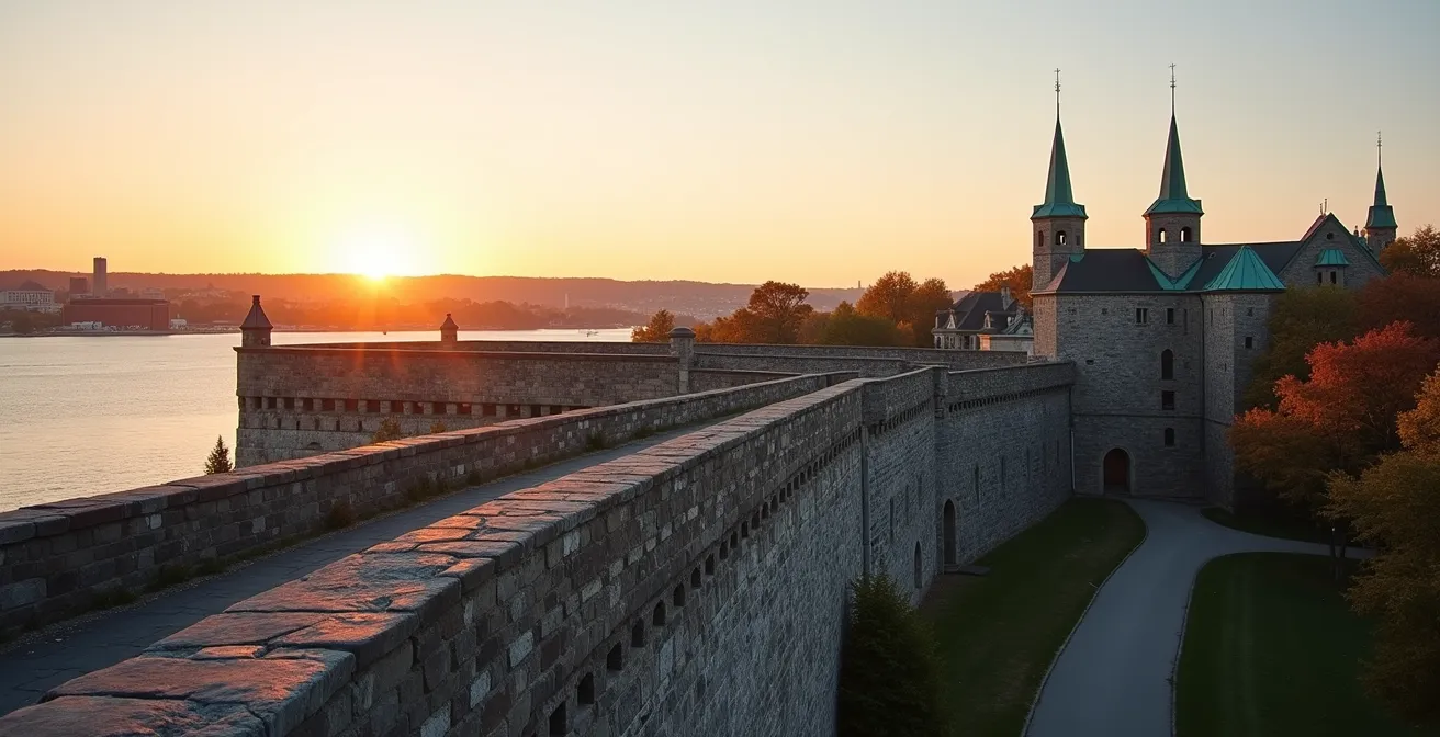
To walk the ramparts of Old Quebec is to trace the most complete and formidable defensive perimeter in North America. For many, it’s a charming 4.6-kilometre journey filled with breathtaking views of the St. Lawrence River and the storybook architecture of the only walled city north of Mexico. Most of this walk is entirely free, offering an unparalleled urban exploration. Visitors often seek out the Changing of the Guard or the best photo of the Château Frontenac, ticking off items from a travel checklist.
But these stone walls hold more than just pretty views. They are a readable textbook of military history, social hierarchy, and the very events that forged modern Canada. The common approach misses the genius behind the design. It sees a wall, but not the strategic kill zones. It sees a funicular, but not the social stratification it was built to overcome. It hears about a brief battle, but doesn’t understand the tactical decisions that made it so devastatingly quick.
This guide changes that perspective. We will move beyond a simple stroll and embark on a strategic exploration. We are not just walking the walls; we are reading them. You will learn to see the fortifications as their military architects did: a complex weapon system integrated with the natural landscape. You will understand why the Citadelle is a star, how a social divide was carved into the cliffside, and why a 20-minute clash of armies on a nearby field determined the fate of a continent.
This article is structured to guide you through these layers of history and strategy. From practical advice on navigating the ramparts to deep dives into the military and cultural significance of each major site, you will gain a profound understanding of what makes Old Quebec so unique.
Summary: A Walker’s Guide to Quebec’s Military History
- How to Walk the Fortifications with a Stroller or Wheelchair
- Why the Citadelle is Shaped Like a Star: A Defense Explanation
- When to Arrive for the Changing of the Guard to Get a Good View
- Upper Town vs. Lower Town: How the Funicular Connects History
- The 3 Best Angles to Photograph the Château Frontenac from the Walls
- Why the Battle of the Plains of Abraham Changed North America in 20 Minutes
- Architecture by the Water: The Best Route to See the Glass Towers
- Exploring Colonial Heritage Sites: A Critical Look at History
How to Walk the Fortifications with a Stroller or Wheelchair
Quebec’s historic character, with its cobblestones and steep hills, can seem daunting for visitors with strollers or wheelchairs. However, a strategic approach makes the city’s ramparts surprisingly accessible. The key is to leverage modern infrastructure and plan your route in segments. Forget trying to conquer the full 4.6 km in one go; instead, focus on the most rewarding and accessible sections. The city has made significant efforts to open its history to everyone, and a little planning unlocks it all.
The most crucial tool is the Funicular, which connects the Lower Town (Petit-Champlain) to the Upper Town (Dufferin Terrace). This single ride eliminates the formidable “Breakneck Stairs” and other steep climbs. In a significant gesture of inclusion, Quebec City’s commitment to accessibility includes free admission for wheelchair users on this historic funicular, turning a physical barrier into a welcoming gateway. Once in the Upper Town, the wide, paved expanse of Dufferin Terrace offers a smooth and spectacular portion of the fortifications walk, with stunning views of the Château and the river.
From there, prioritize paved sections. Rue des Remparts offers a beautiful, mostly flat walk along the northern walls. For accessing the higher fortifications near the Citadelle, use designated accessible parking as a base. By splitting your tour—perhaps focusing on the Dufferin Terrace and Rue des Remparts in one outing and the area around the Citadelle in another—you can experience the grandeur of the walls without the exhaustion. Visiting in the shoulder seasons of late spring or early fall also helps, as you’ll avoid both the dense summer crowds and treacherous winter ice, ensuring a safe and pleasant exploration.
Why the Citadelle is Shaped Like a Star: A Defense Explanation
From the ground, the massive stone walls of the Citadelle of Quebec are imposing. But from above, their true genius is revealed: a nearly perfect star shape. This is no aesthetic choice. It is the pinnacle of a military design philosophy perfected by the French marshal Vauban, engineered to create an unassailable fortress. The pointed bastions of a star fort are designed to eliminate “dead zones”—areas where attackers could hide from cannon fire. Each wall, or “curtain,” is protected by the flanking fire of two bastions, creating overlapping fields of fire that make a direct assault suicidal.
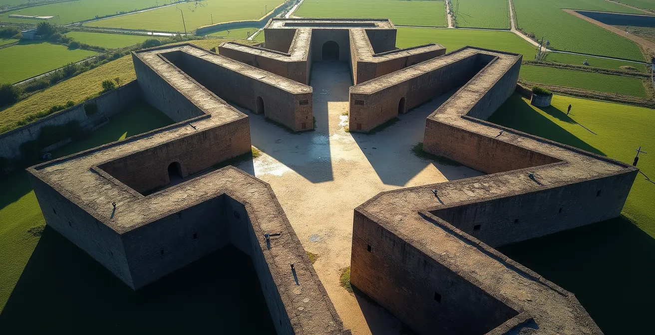
The Citadelle of Quebec, built by the British between 1820 and 1850, is a masterful adaptation of this European concept to Canadian geography. It represents the largest British fortress built in North America. The design cleverly uses the strategic topography of Cape Diamond; one side is a sheer 90-metre cliff dropping to the river, a natural and impenetrable wall. Therefore, the star-shaped defenses are concentrated on the west, facing the flat, vulnerable Plains of Abraham. The fortress was a direct response to the threat of an American invasion following the War of 1812.
This design incorporated and enhanced earlier French engineering. An underground artillery battery, known as a flank blockhouse, was built in the 1750s. This feature effectively doubled the firepower at the fortress’s weakest points. Its embrasures (openings for cannons) were angled to create a crisscrossing storm of projectiles. Any attacking force attempting to scale the walls would be caught in this inescapable, geometric crossfire. The star shape is, therefore, the ultimate expression of defensive mathematics, turning stone and geometry into a formidable weapon.
When to Arrive for the Changing of the Guard to Get a Good View
The Changing of the Guard ceremony at the Citadelle is a spectacular display of military tradition, performed daily in the summer at 10:00 AM. It’s a popular event, and arriving at 9:55 AM often means peering over a sea of heads. To transform your experience from a glimpse to a front-row spectacle, you must think like a military strategist and secure your position early. A little planning guarantees an unforgettable view of the pageantry.
The ceremony is performed by the Royal 22e Régiment, affectionately known as the “Van Doos.” It is a point of pride that, as Destination Canada highlights, they are the only solely French-language infantry regiment in the Canadian Armed Forces. This adds a unique cultural and linguistic layer to the formal British-style ceremony, complete with scarlet tunics, bearskin hats, and the regimental mascot, a goat named Batisse. Understanding this context enriches the viewing experience.
To get the best possible view, you need a clear plan of action. Simply showing up isn’t enough; you need to choose your viewing spot with intent.
Your Action Plan: Securing the Best View of the Ceremony
- Arrive 45 minutes early (9:15 AM): This is non-negotiable for the best spot. Claim a position directly centered in front of the parade square. This gives you a completely unobstructed, symmetrical view of the entire ceremony.
- Arrive 15 minutes early (9:45 AM): If you’re later, all is not lost. Position yourself at the side angle near the museum entrance. This offers excellent visibility as the soldiers march and perform their drills.
- Consider an alternative view: For a unique perspective, watch the Van Doos assemble on the outer walls of the Citadelle *before* they march onto the main parade square. You’ll see the behind-the-scenes preparations.
- Employ a post-ceremony strategy: Don’t rush off with the crowds. Stay for 15 minutes after the ceremony ends. This is the perfect time to photograph the soldiers at their posts or even speak with them as they relax.
- Confirm the schedule: While the 10:00 AM summer time is typical, always check the official Citadelle website before your visit, as schedules can change due to weather or official functions.
By adopting this tactical approach, you ensure the Changing of the Guard is not just something you see, but something you experience up close and personally.
Upper Town vs. Lower Town: How the Funicular Connects History
Quebec City’s most dramatic feature is its division into an Upper Town (Haute-Ville) and a Lower Town (Basse-Ville), separated by the sheer cliff of Cape Diamond. This is not just a geographical feature; it is a physical manifestation of centuries of historical stratification. The funicular, a cable car that glides effortlessly between the two, is more than a tourist convenience—it is a modern bridge across a deep historical and social divide. To ride it is to travel between two distinct worlds that defined colonial life.
The Upper Town, perched atop the cliff, was the seat of power. It housed the colonial government, the military leadership, and the religious authorities. Its grand institutional buildings, like the Cathedral-Basilica of Notre-Dame de Québec and the governor’s residence (on the site of the Château Frontenac), projected authority and prestige. The Lower Town, nestled by the river, was the realm of merchants, sailors, and artisans. It was the commercial engine of New France, with narrow, bustling streets, stone merchant houses, and the lively Place Royale. The original connection was the infamous L’Escalier Casse-Cou, or “Breakneck Stairs,” a name that vividly captures the precarious daily journey for the working class.
The funicular, first built in 1879, effectively democratized this vertical divide. What was once a strenuous climb became a 60-second ride. This table breaks down the fundamental differences between the two districts:
| Aspect | Upper Town (Haute-Ville) | Lower Town (Basse-Ville) |
|---|---|---|
| Historical Function | Seat of religious and political power | Commercial hub and working-class quarters |
| Key Buildings | Château Frontenac, Citadelle, Cathedral | Place Royale, Petit-Champlain, Old Port |
| Elevation | On 90-meter cliff (Cape Diamond) | At river level |
| Modern Access | Via funicular, stairs, or steep streets | Direct street level access |
| Architecture Style | Grand institutional buildings | Narrow streets, stone merchant houses |
Today, as you glide up in the funicular, you are retracing a journey of social mobility. You move from the commercial heart of the colony to its political and spiritual head, witnessing how Quebec’s very layout was designed to reflect power and class.
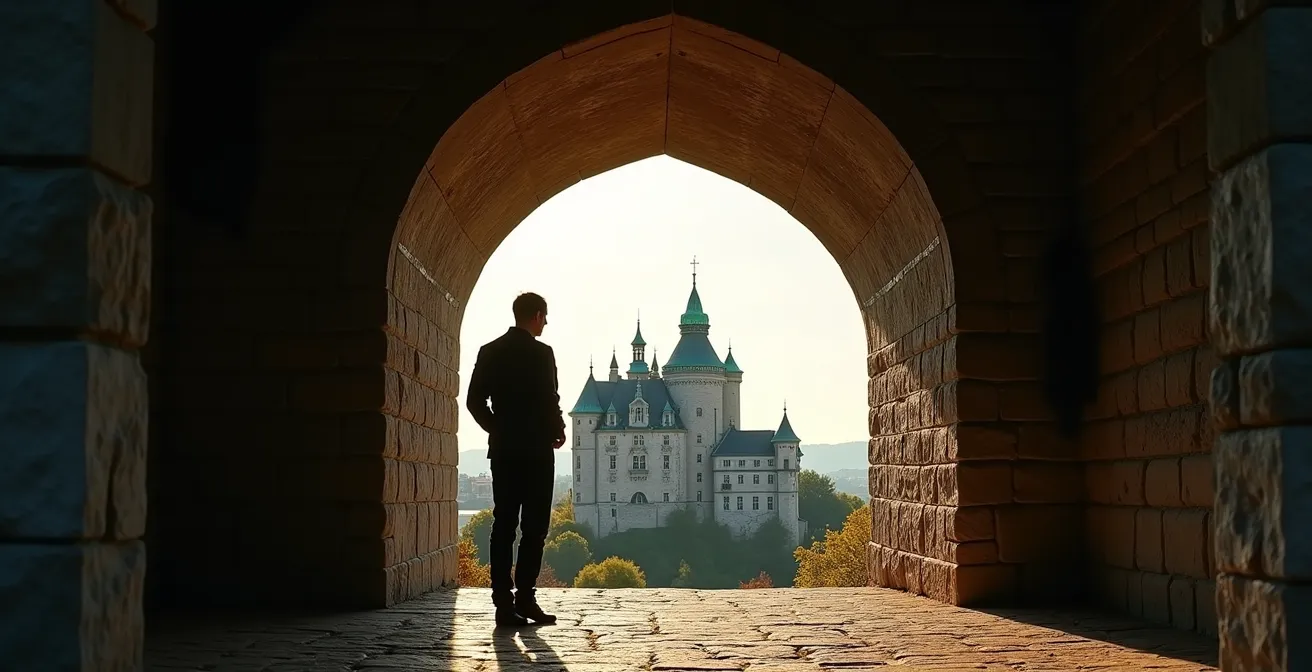
The 3 Best Angles to Photograph the Château Frontenac from the Walls
The Château Frontenac is one of the most photographed hotels in the world, and the fortifications of Quebec offer a magnificent, elevated stage from which to capture its iconic silhouette. However, simply pointing your camera from the wall often results in a flat, uninspired image. To create a truly professional-quality photograph, you must use the walls themselves as a compositional tool—framing, compressing, and providing context to the grand hotel. A photographer, like a general, must choose their ground carefully for the best result.
The key is to think in terms of foreground, mid-ground, and background. The walls and their features (cannons, archways) can provide a powerful foreground that adds depth and a sense of history to your shot. Different lenses will also produce dramatically different results. A wide-angle lens emphasizes the expanse, while a telephoto lens compresses distance, making the Château appear closer and more imposing relative to its surroundings. Here are three specific, proven angles to capture a magazine-worthy shot.
Each of these locations offers a unique narrative. They don’t just show the Château; they tell a story about its relationship with the city, its military past, and the river that defines it. Use this list as your photographic battle plan:
- The Citadelle Crown Shot: For this, you must enter the Citadelle (ticket required) and make your way to the King’s Bastion. This is the highest point of the fortifications. Using a standard zoom lens (like a 24-70mm), you can capture a breathtaking panoramic view where the Château appears as the crown jewel of the Old City, with the St. Lawrence River stretching out behind it.
- The Dufferin Terrace Compression: Walk to the far eastern end of Dufferin Terrace. From here, use a telephoto lens (70-200mm) and zoom in on the Château. This technique compresses the perspective, making the hotel appear stacked against the buildings of the Lower Town and the distant shoreline of Lévis, creating a rich, layered composition.
- The Artillery Park Frame: Head to the western section of the walls near Artillery Park. This area is dotted with historic cannons and weathered stone doorways. Use these elements to frame the distant Château. A shot through an archway or over the barrel of a cannon connects the city’s landmark hotel directly to its military heritage.
Why the Battle of the Plains of Abraham Changed North America in 20 Minutes
The Battle of the Plains of Abraham is often cited as a pivotal moment in Canadian history, but its legendary brevity—often quoted as lasting a mere 20 minutes—is frequently misunderstood. That timeframe refers only to the main, decisive exchange of gunfire, not the entire siege of Quebec. The battle’s true significance lies in its brutal efficiency and its world-altering consequences. It was a textbook example of 18th-century line battle tactics, and its outcome directly led to the end of New France and the birth of a bicultural Canada.
The stage was set on September 13, 1759. British General James Wolfe, after a long siege, made a daring move, scaling the cliffs west of the city to assemble his army on a farmer’s field known as the Plains of Abraham. The French commander, the Marquis de Montcalm, was forced to rush out of the city’s defenses to meet them. The British troops stood in a famously thin, two-deep red line, waiting silently as the French and Canadian militia advanced. They held their fire until the French were just 40 yards away.
When the order was given, the British unleashed a single, perfectly coordinated volley. Their muskets were loaded with two balls instead of one, creating a devastating shotgun-like effect that shattered the advancing French lines. This single, disciplined act of firepower caused mass casualties and immediate chaos. A second volley quickly followed, breaking the French charge completely and turning the battle into a rout. This is the “20 minutes” of history: a short, sharp, and decisive encounter defined by superior British discipline and firepower. Both Wolfe and Montcalm were mortally wounded, becoming martyrs for their respective empires. The battle’s continental impact is measured not just in its brevity, but by the 4-year period from the Battle to the Treaty of Paris that formally transferred Canada from France to Great Britain in 1763. The subsequent Quebec Act of 1774, guaranteeing French language and civil law rights, set the stage for Canada’s enduring English-French duality.
Architecture by the Water: The Best Route to See the Glass Towers
While Old Quebec is defined by its historic stone ramparts, a walk along the waterfront reveals a fascinating architectural dialogue between past and present. The modern glass towers of the Old Port area and the sleek lines of the waterfront promenade stand in stark, beautiful contrast to the centuries-old fortifications looming above. To truly appreciate this contrast, you need a specific route, timed perfectly with the setting sun. This walk is not about choosing one style over the other, but about seeing how they complement and reflect one another.
The goal is to capture the moment when stone and glass are in perfect harmony, a visual conversation between a fortified past and a transparent future. The St. Lawrence River acts as a grand mirror, doubling the beauty of the scene. This is a walk for photographers and lovers of urban design, a path that reveals a different side of Quebec’s identity.
Follow this route to experience this architectural dialogue at its most dramatic. It’s a journey from the golden light of history to the glowing blue of modernity, all within a short, scenic walk.
- Start at the Old Port one hour before sunset. This is the golden hour, when the warm, low light illuminates the historic stone of the ramparts, making their texture and age stand out.
- Walk along the waterfront promenade. This path is perfectly positioned for you to capture the reflections of the modern glass towers in the calm waters of the Bassin Louise. The juxtaposition of the sleek, reflective surfaces against the solid, matte stone is striking.
- Find “dialogue” compositions. Position yourself at angles where the modern towers align with or are framed by the historic walls. This creates a powerful “dialogue-between-centuries” photograph, telling the story of the city’s evolution.
- Continue as the sun sets. As the sky darkens, you’ll witness the transition. The stone walls recede into silhouette while the glass buildings, lit from within, begin to glow, transforming the skyline.
- End at a panoramic viewpoint. Conclude your walk at a spot where both architectural styles are visible in their best light—the old city dark and majestic, the new port bright and dynamic.
Key takeaways
- Strategic Planning: Viewing Quebec’s walls as a military system, not just a scenic path, unlocks a deeper understanding of the city’s history and design.
- Topography is Destiny: The city’s layout and the fortress’s design were dictated by the natural advantages and vulnerabilities of Cape Diamond and the Plains of Abraham.
- Legacy and Adaptation: Colonial-era structures, from the funicular’s path to the fortifications themselves, have been repurposed and reclaimed as vital elements of modern Quebecois cultural identity.
Exploring Colonial Heritage Sites: A Critical Look at History
The fortifications of Quebec are not a neutral historical artifact. They are a powerful symbol of colonial conquest, imperial ambition, and military control. Yet, paradoxically, they have become the city’s most cherished cultural asset and a UNESCO World Heritage site, beloved by the very people whose ancestors they were built to subdue. To explore these sites is to confront this complex and fascinating legacy, a story of how instruments of power are transformed into places of cultural celebration.
In 1960, during the inauguration of the Governor’s Walkway, Canadian Prime Minister John Diefenbaker captured this sentiment perfectly. For him, the visit was more than a tour; he described it as:
A visit to Québec City was ‘like a pilgrimage to the cradle of our nation’
– Prime Minister John Diefenbaker, Governor’s Walkway Inauguration Speech, 1960
This idea of the city as a “cradle” speaks to its foundational role in the Canadian story. However, this cradle was forged in conflict. The most compelling example of this transformation is the work of Lord Dufferin, a Governor General of Canada in the 1870s. When parts of the walls were threatened with demolition in the name of progress, it was Dufferin, an administrator of the British Empire, who championed their preservation and restoration.
This presents Lord Dufferin’s Paradox: a colonial representative preserving the very symbols of British conquest, which have since become emblems of Quebecois identity and heritage. The walls that once enforced a rigid social hierarchy—separating the fortified, elite Upper Town from the world outside—are now the backdrop for vibrant cultural events. Today, the world-renowned Festival d’été de Québec uses these colonial structures as stages and backdrops for contemporary Francophone music and art. Military architecture has been reclaimed and transformed into a space for cultural expression, a testament to the resilience and adaptability of Quebec’s culture. Walking the walls today is an act of participating in this living history.
By viewing the walls through this strategic and historical lens, your visit to Old Quebec transforms from a simple sightseeing tour into a deep, meaningful exploration of the forces that shaped a city and a nation. The next logical step is to walk these ramparts yourself, armed with this new perspective, and read the stories written in stone.